Photo: RNZ
More than a third of the population in some regions are at risk from inland flooding and that will increase as a changing climate brings wilder, wetter weather, new data shows.
Earth Sciences New Zealand (formerly NIWA) has just released the first-ever national model of flood risk across the entire country, along with a public flood hazard viewer so people can see their area's risk compared to elsewhere in Aotearoa.
The researchers involved hope the information will guide better decisions about where to prioritise climate adaptation - and where to avoid future development.
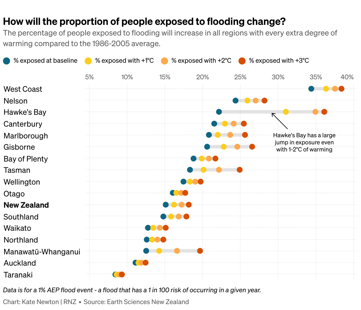
The data shows that nationwide, 750,000 people, or 15 percent of the population, are already at risk from a major rainfall or river flooding event - one that has a one in 100 chance of occurring in any given year. The number of people exposed rises steadily to more than 900,000 with 3°C of warming.
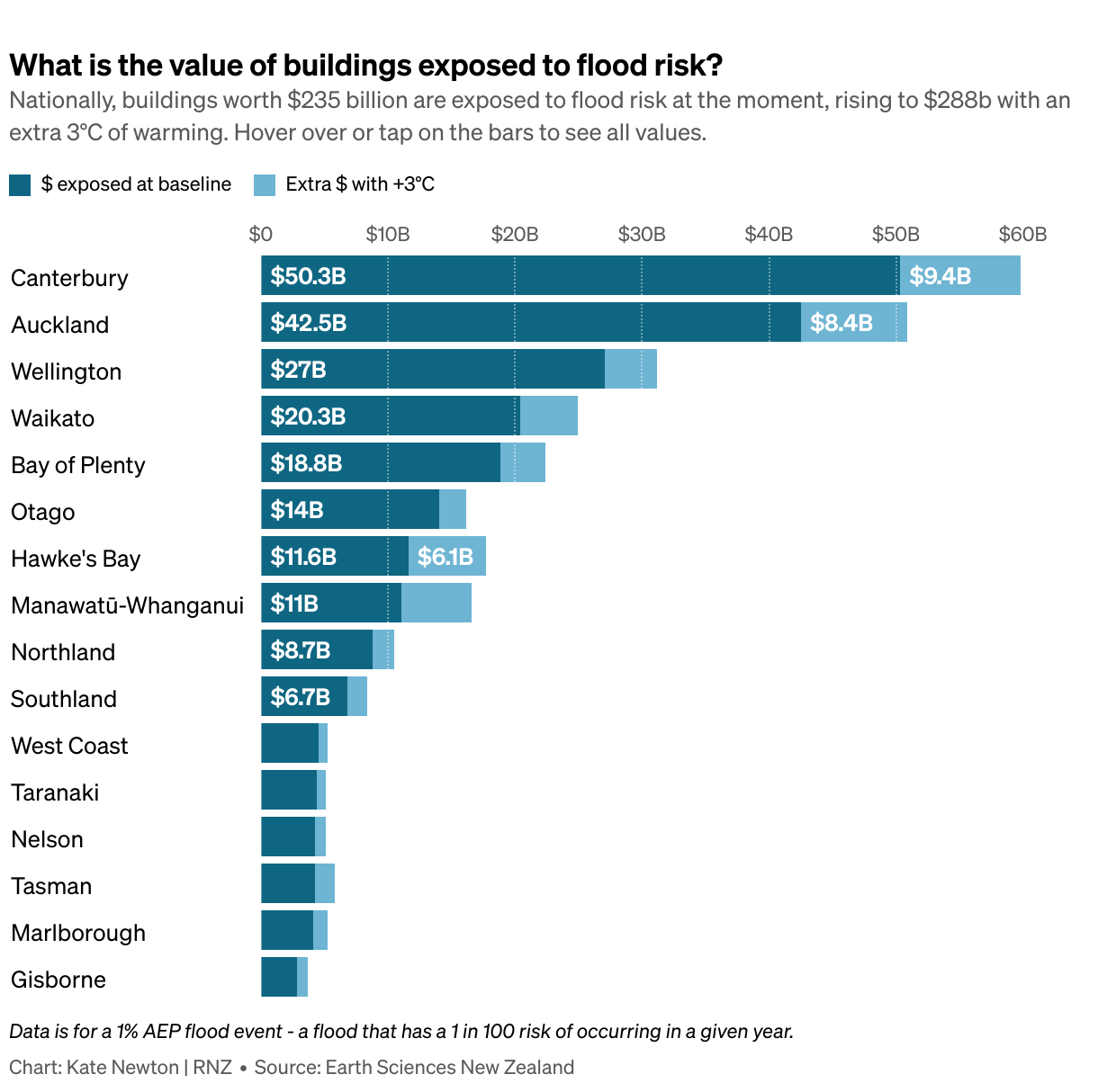
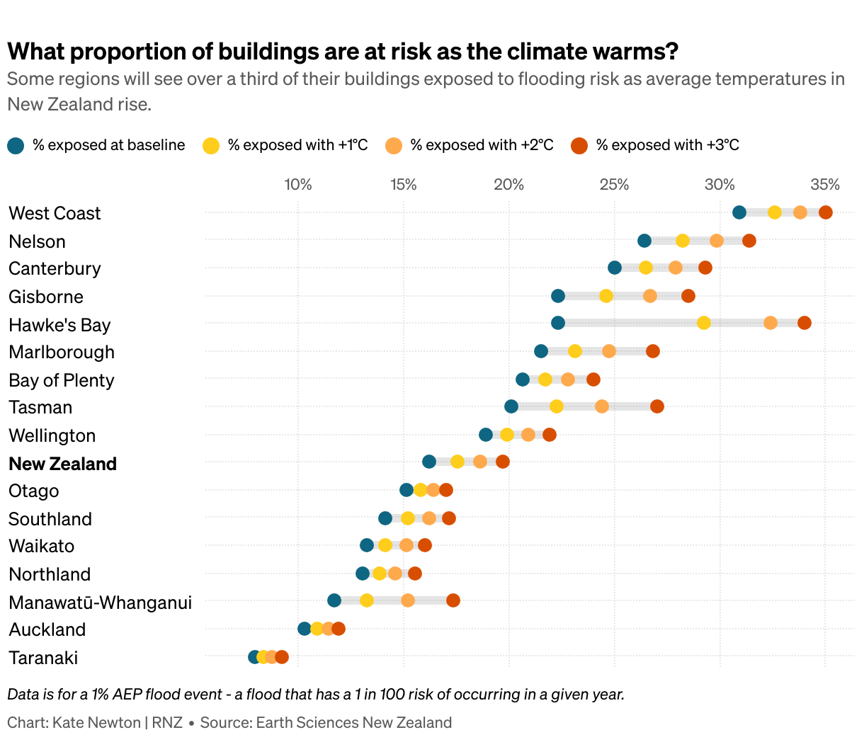
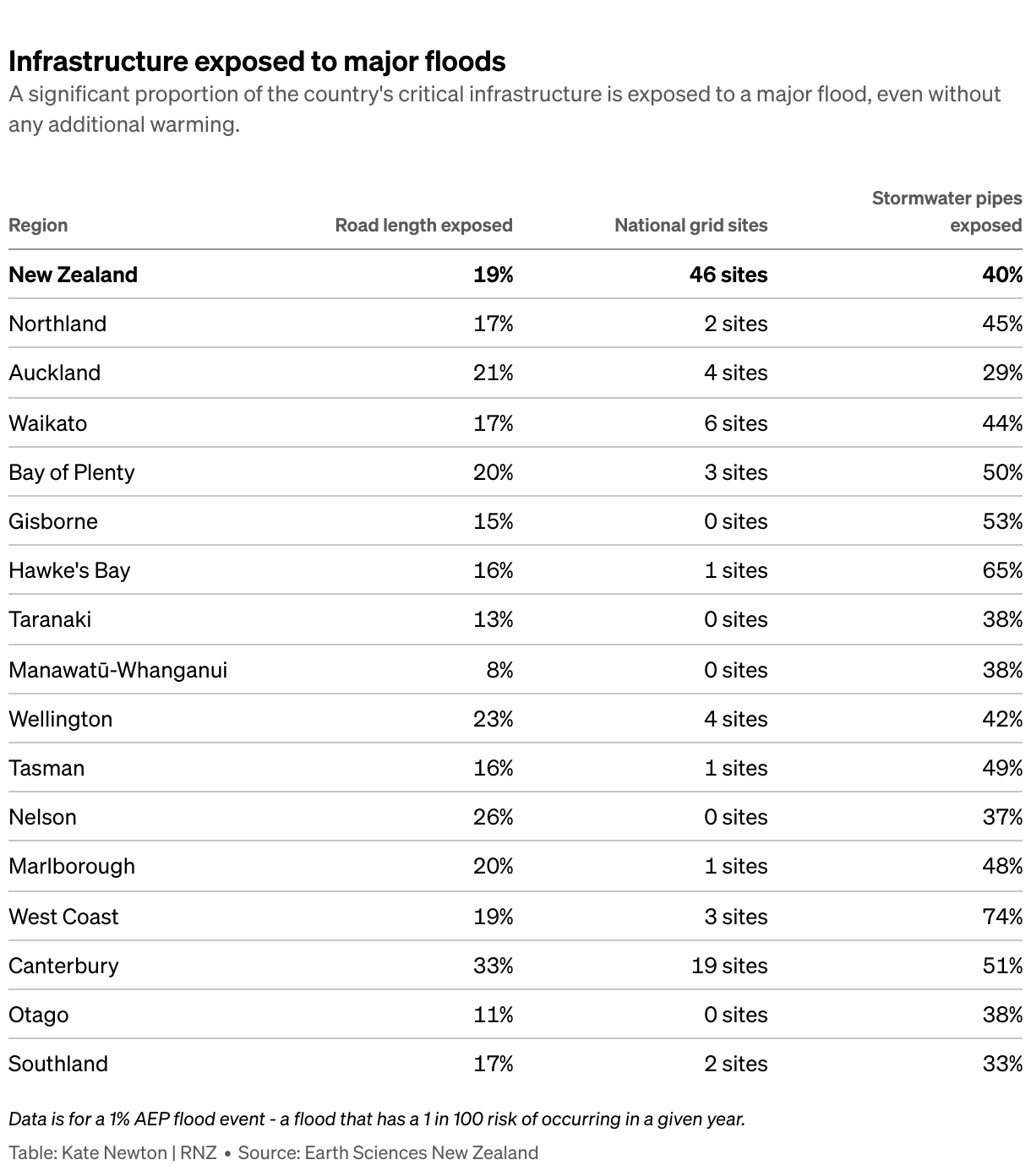
The data also includes the number and value of buildings exposed, and other crucial infrastructure, such as thousands of kilometres of roads and stormwater pipes, that are at risk.
$235 billion of buildings are exposed at the moment, rising to $288bn with an additional 3°C of warming.
There are big jumps in risk for some areas as the climate warms, bringing more extreme weather events with it.
In Hawke's Bay, where Cyclone Gabrielle caused an estimated $14bn of damage, the proportion of the population exposed rises from 22 percent to 31 percent with just one degree of warming above the 1986-2005 average.
That warming could happen as soon as 2029 if emissions are not curbed.
Earth Sciences principal scientist Emily Lane, who led the five-year project, said climate change was one part of the picture.
"We know rainfall intensity is increasing across Aotearoa, with more rain falling in shorter periods. Rapid urban intensification is another contributing factor."
The flood hazard viewer was not designed to replace the very detailed hazard maps or Land Information Memorandum (LIM) information that some regional council areas already published, she said.
However, it was the first time that consistent information has been published for the whole country.
"If you're trying to compare across different regional councils or across different regions, you can't do it at the moment because there's so many differences in terms of whether it's done, how it's done, [and] what is actually done," Lane said.
For some regions, it was the first time any kind of public map of flood risk had been made available - including the West Coast, which is the most exposed region on most measures in the data.
"We've been making those national-scale adaptation decisions in a vacuum," Lane said. "We haven't had the consistent information to be able to make them well."
That had created a risk of adapting in the wrong places first, she said.
"Those that already have [hazard modelling] will get more because they've already been able to show that this place needs adaptation, whereas there might be other places that require it even more but haven't actually got the resources to be able to put that case."
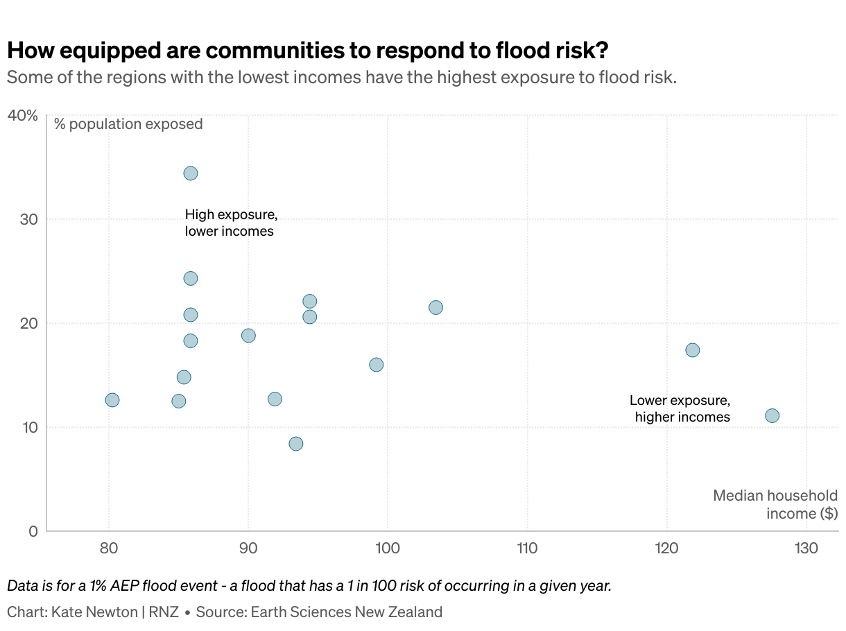
The research, which was funded by the Ministry of Business, Innovation and Economic's Endeavour Fund. showed that some of the regions most at risk are those least financially equipped to cope.
On the West Coast, which has lower-than-average median incomes and a small ratepayer base, 34 percent of the population was already exposed.
Speaking at the Adaptation Futures conference in Christchurch earlier this month, former Buller District Council mayor Jamie Cleine cried while talking about the risks facing Westport.
Flooding in the town had escalated in recent years and the council signed off on a plan earlier this year that could see it relocate entirely.
Lane said often the people living within floodplains were the ones who could least afford to leave.
"That is something that does weigh down on me. But I think the more that the government and regional councils and the people themselves are aware of where these places are, the more we can actually start making the right decisions for adaptation and to actually move ourselves into a safer configuration."
Earth Sciences natural hazards researcher Ryan Paulik, who helped model the risk to buildings, agreed that cost was a major barrier to adaptation in some areas.
"With lower ratepayer base, then the ability to afford structural or non-structural interventions to reduce flood risk or manage flood risk, there's fewer options unless that funding can be sourced."
Earlier this month, the government released its National Adaptation Framework, which set out some broad principles for how New Zealand will adapt to climate change-related hazards.
It requires councils to produce adaptation plans in the highest priority areas, with financial assistance for some projects available through the pre-existing $1.2 billion regional infrastructure fund.
In the meantime, communities should be limiting any further risk, Paulik said.
"How we develop in and around floodplains is what's going to be driving the potential losses in the future as opposed to the increasing magnitude of the hazard."
Greater Wellington resilience lead Andy Brown said New Zealand was "very good at developing on the lovely flat land next to rivers".
That had to stop.
"The strongest thing we can do now is to not put new developments in any of those currently flood prone areas. So when we're looking at big developments, using something like this tool to be able to go, okay, let's avoid these certain areas and not even plan to go into them."

The flood hazard viewer, which shows the projected depth of water in a major flood now and with additional warming, is available on Earth Sciences New Zealand's website. Photo: ESNZ/Screenshot
Greater Wellington and other regional councils had worked with Earth Sciences throughout the project and would be responsible for explaining how the new information fitted into what people knew about their area already, he said.
It could be "challenging" to tell people they were living in a hazard zone.
"As soon as you start putting lines on maps, it affects the way people are able to develop, the house prices, potentially insurance - although they do some of their own modelling," Brown said.
"So when we communicate flood hazard, there's a lot of sensitivity in how we do it because of that risk, but I would say that understanding flood hazard is the most important thing we can do."
The Earth Sciences data and flood hazard viewer is separate to a planned National Flood Map, proposed under the new adaptation framework.
That map - which Earth Sciences confirmed it planned to bid for - would also include coastal flooding from sea level rise and storm surges, and show risk right down to individual property level.
The Earth Sciences model included rainfall and other data for more than 250 floodplains around New Zealand, and took into account tide data at river mouths and many flood defences such as stopbanks.
Ryan Paulik said as well as showing risk across the country, it could also be used to predict the damage and cost of a particular flooding scenario.
That would be useful for deciding if a particular flood defence or adaptation plan was cost-effective, he said.
"Are they going to pay off over time economically, but also are they going to pay off over time based on the improved outcomes for communities based on reduced or managed flood risk?"
Sign up for Ngā Pitopito Kōrero, a daily newsletter curated by our editors and delivered straight to your inbox every weekday.